
Aerial Filmmaking Production Portfolio
Tywi: Oxbow Lakes
Operations Manual
View the operations manual here: Click Here
Synopsis
Tywi: Oxbow Lakes
This segment of a video series embarks on an aerial journey to uncover the hidden treasures of the Towy River's ecosystem. Utilising drone footage, it discusses the Oxbow lakes, which have been formed by the ever-changing course of the longest river entirely within Wales.
The video showcases the Towy River snaking its way through the picturesque Welsh countryside. We are introduced to the concept of Oxbow lakes, intriguing geological formations that are dotted along the farmland that flanks the river Towy.
Through imagery, we witness the intricate dance between the Towy River and the surrounding landscape. The video shows how the river's constant movement and erosion processes have shaped the formation of Oxbow lakes over time. These lakes, characterised by their horseshoe-like shape, are created when the river's meander loop is cut off, leaving behind a calm body of water.
By using a birds eye view from the drone, we are presented with a captivating panorama of these unique habitats. The video showcases the lakes' calm waters, which provide a sanctuary for a diverse array of flora and fauna. The narration highlights the significance of these ecosystems, emphasising their role as crucial breeding grounds and nurseries for various species.
Rationale
The purpose of this rationale is to justify the creation of a video that explores the oxbow lakes adjacent to the River Towy. Oxbow lakes are fascinating geographical formations that offer unique insights into the dynamic nature of river systems. By highlighting the significance of these lakes and their relationship with the River Towy, as well as the ecology and habitat the Oxbow Lakes provide, this video aims to educate and engage viewers, fostering a deeper appreciation and awareness for the natural wonders that exist within our local area.
1. Educational Value:
The video will serve as an educational tool, providing viewers with valuable information about the formation and significance of oxbow lakes. By explaining the geological processes that lead to their creation as well as the valuable habitat their provide, viewers will gain a better understanding of the complex interactions between rivers, their surrounding landscapes and the flora and fauna that inhabit them. This knowledge will contribute to a broader understanding of natural processes and foster a sense of environmental stewardship.
2. Environmental Awareness:
The video will raise awareness about the importance of preserving and protecting oxbow lakes. By showcasing the unique flora and fauna that inhabit these ecosystems, viewers will develop a greater appreciation for the biodiversity that thrives in these environments. This increased awareness can inspire individuals to take action in conserving these fragile habitats, contributing to the overall preservation of our natural heritage.
3. Aesthetic Appeal:
The use of a drone and aerial footage will enhance the visual appeal of the video. By capturing the oxbow lakes from above, viewers will be able to appreciate the intricate patterns and shapes formed by the meandering river and the lakes it has left behind. This perspective will provide a comprehensive view of the landscape, allowing viewers to fully grasp the scale and beauty of these formations. The aerial footage will also enable the video to showcase the surrounding natural scenery, including the lush vegetation and diverse wildlife that thrive in these areas.
4. Unique Perspective:
Utilising a drone and aerial footage will offer a unique perspective that is not easily achievable through traditional filming methods. The ability to capture sweeping shots of the oxbow lakes and the River Towy from various angles and heights will provide viewers with a comprehensive understanding of the landscape (Newall, 2016). This immersive experience will allow viewers to feel as though they are flying above the lakes, enhancing their connection to the environment.
Conclusion:
In conclusion, the creation of a video exploring the oxbow lakes next to the River Towy is justified due to its educational value, environmental awareness potential, aesthetic appeal, and unique perspective. By utilising a drone and aerial footage, the video will provide viewers with a comprehensive understanding of these geological formations, their ecological importance, and the beauty of the surrounding landscape. This video will not only educate and engage viewers but also inspire them to appreciate and protect the natural wonders that exist within our environment.
Mood Board
(Netflix, 2019)
This clip from Our Planet is a good example of an expository style documentary (Masterclass, 2021) that uses drone footage to aid in showing the subject from a perspective that allows the viewer to visually understand the subject more comprehensively.
(National Geographic India, 2022)
This video by National Geographic India is a good example for my mood board as the subject of this documentary is also a river and includes the ecology and habitat it provides.


Above Images: Daniel James Phillips - Fishing on the River Towy.
The above imagery is an example of the ideal weather conditions I would have for the film, as well is showing the location and colour grading similar to what I would like.
Shot List
1. Establishing Orbital Drone Shot: Aerial view of the surrounding landscape, showcasing the natural beauty of the area.
2. Wide Drone Shot: Slowly descend towards the first oxbow lake, capturing its curved shape and reflecting the surrounding vegetation.
3. Low-Level Drone Tracking Shot: Follow the shoreline of the oxbow lake, highlighting the lush greenery and diverse wildlife inhabiting the area.
4. High-Level Overhead Drone Shot: Ascend above the oxbow lake, capturing its full extent and showcasing the unique formation caused by the meandering river.
5. Close-Up Shot: Focus on the crystal-clear water of the oxbow lake, revealing the mesmerizing reflections of the sky and surrounding trees.
6. Panoramic Shot: Slowly pan across the oxbow lake, capturing the intricate details of the shoreline, such as fallen trees and reeds.
7. Point-of-View Drone Shot: Fly the drone through the meandering path of the oxbow lake, providing a dynamic perspective of the surrounding landscape.
8. Time-Lapse Shot: Set up the drone in a fixed position, capturing the movement of clouds in the sky and ripples across the waters surface created by wind.
9. Bird's Eye View Shot: Ascend to a higher altitude, capturing multiple oxbow lakes in the area, showcasing their interconnectedness and natural patterns.
10. Tracking Shot: Follow a group of birds or wildlife from a safe distance as they move along the shoreline, showcasing the diverse ecosystem supported by the oxbow lake.
11. Slow Motion Shot: Capture the ripples and splashes created by a jumping fish or a water bird taking off from the lake's surface.
12. Silhouette Shot: Film the reflection of the sunset or sunrise on the water, capturing the serene and picturesque atmosphere of the oxbow lake.
13. Revealing Shot: Start with a close-up of a flower or plant at the water's edge, then slowly reveal the entire oxbow lake in the background.
14. Cinematic Flyby Drone Shot: Fly the drone along the length of the oxbow lake, creating a cinematic and immersive experience for the viewer.
15. Closing Drone Shot: Ascend to a high altitude, capturing the entire landscape with multiple oxbow lakes, leaving the viewer with a sense of awe and appreciation for the natural wonders of these formations.
Safety/Drone Law Research
CAA Guidelines state that “If your drone has a camera (unless it is a toy) or weighs 250g or more then you need to register with the CAA. You need to renew this registration every year. This is a registration of you as the operator rather than the drone itself.” (CAA, 2023) The drones I fly for filmmaking all have cameras, therefore I must have a flyer ID in order to take photos or video with a drone.
According to UAVHUB it is a legal requirement to get permission from the land owner before taking off or landing your drone. (UAVHUB, 2023)
As the land that the oxbow lakes are on belongs to the National Trust I will have to film from the opposite side of the river (where I have permission to fly). I can’t fly or film from the drone over National Trust land due to their rules on commercial photography/filming and flying drones at their property (National Trust, 2023)
It would be possible to make a film on behalf of the National Trust if there were to approach me and commission me to do so, but this would only be the case if I had the appropriate qualifications and insurances.
Planning
Picking my drone
The drone I will be using for this film is the DJI Mavic Air 2. This drone falls in to the A2 subcategory, meaning that I need to have the user manual available, have completed the drone registration (DEMARES) test, completed self practical training and hold an A2 CofC certificate in order to operate. (heliguy, 2023)
This means that in order to film using the DJI Mavic Air 2 I will need to secure A2 CofC certification prior to the shoot.
Research on cinematic drone footage
(Dovey, 2021)
I plan to use some of the shot types Javen discusses in this video in my film. For example I will use an Orbital shot for my opening establishing shot. I feel that this type of shot will set the scene immediately, showing the main subject and it’s context in the larger landscape. I hope that this will immediately grab the viewers attention.
(Full Time Filmmaker, 2020)
I found this video by Full Time Filmmaker very useful. The tips they discuss include shooting in Log format, which is something I will do so that I can colour grade the footage in order to achieve the look that I want.
They also discuss the use of ND filters in order to achieve the desired shutter speed so that there is no “jittery’ footage. This is something I will consider, they may or may not be necessary depending on the weather of the day. I will carry ND filter suitable for my drone in case they are needed.
(Dovey, 2022)
I would like to use something similar to shot number 7 on the above video. A birds eye rotation view of the oxbow lakes. I feel that this shot would show, in an abstract way, the intricate patterns the river and lakes create together.
This video is very useful in order to have a good idea of a wide range of drone and camera movements I can utilise in the video.
Drone Assist


Drone assist shows the National Trust property as an SSSI, as well as the Towy River itself as an SSSI. The CAA suggests that there may be restrictions on SSSIs but directs that it be checked with the relevant authority, I don’t plan to fly over the National Trust property so that isn’t an issue and in the case of the river itself, Natural Resources Wales are the relevant authority. (CAA, 2023).
Natural Resources Wales require consent for activities that “are likely to damage the site’s special interest” (Natural Resources Wales, 2023). They state that each site may have a list of these relevant activities . On searching the information on the Towy River SSSI I can’t see that there are any restrictions on flying the UAS.
With the above in mind I believe that it is safe to continue with the plan, however I need to be even more aware of disturbing any fauna or damaging any flora in the area, as well as avoiding flying directly over the river itself.
Weather


The wind speeds are acceptable at 11mph with the drone rated at a maximum of 22.4mph but the rain forecast is changeable. Cross referencing with other forecasting sites such as BBC Weather and the Met Office will allow me to get a better picture and prediction of the days weather, which should allow me to select the most appropriate and safest time to fly.
Lighting etc
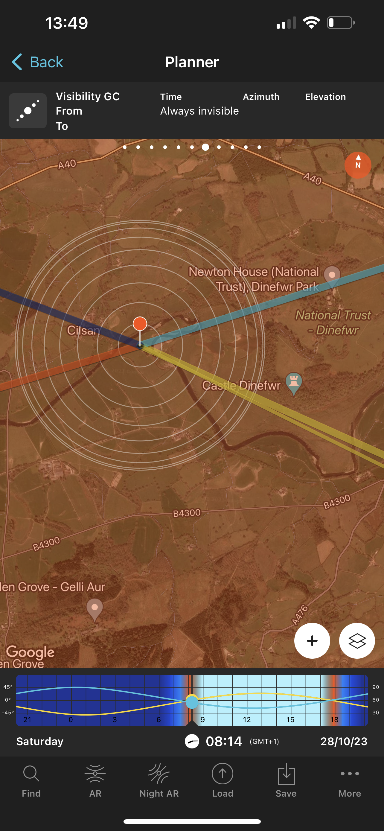
Photo Pills
Using the app PhotoPills, I can see that sunrise is approximately 8am and sunset 6pm. I would like to film at these times in order to get the soft side lighting skimming across the landscape. This helps show the rolling hills and features of the land.
The angle of both sunrise and sunset would work here, but given the orientation of my fly zone to the subject, sunrise would be marginally better.
The main issue in the planning is the weather, finding a window the fly between the bad weather will dictate when the shoot happens more so than the position of the sun.
Reference List:
CAA (2023) Introduction to drone flying and the UK rules. Available at: https://www.caa.co.uk/drones/rules-and-categories-of-drone-flying/introduction-to-drone-flying-and-the-uk-rules/ (Accessed: 31 October 2023).
CAA (2023) Where you can fly drones. Available at: https://register-drones.caa.co.uk/drone-code/where-you-can-fly (Accessed: 31st October 2023)
Dovey, J. (2021) 10 DRONE Moves I Capture With Every Flight [video]. Available at: https://www.youtube.com/watch?v=6PXYa4HupEc (Accessed: 31 October 2023)
Dovey, J. (2022) 25 Drone Moves For Cinematic B Roll [video]. Available at: https://www.youtube.com/watch?v=00ZNvOMUe0o (Accessed: 31 October 2023)
Full Time Filmmaker (2020) 6 Tips To Improve Your DRONE Footage [video]. Available at: https://www.youtube.com/watch?v=5pOZ9L5cr00 (Accessed: 31 October 2023)
heliguy (2023) UK Drone Laws 2023: Where can I fly?. Available at: https://www.heliguy.com/blogs/posts/uk-drone-laws-where-can-i-fly#:~:text=A2%20Subcategory%20%2D%20Fly%20Near%20To%20People&text=However%2C%20all%20pilots%20must%20have,fly%20in%20the%20A2%20subcategory.&text=Operating%20Area-,No%20flights%20within%20restricted%20airspace%20(Restricted%20Areas%2C%20Danger%20Areas%2C,commercial%2C%20industrial%20and%20recreational%20areas. (Accessed: 31sOctober 2023)
Masterclass (2021) Film Documentary Guide: 6 Types of Documentaries. Available at: https://www.masterclass.com/articles/film-documentary-guide#5Y9BJa4CNL7JdaReeZkcCJ (Accessed: 1 November 2023)
National Geographic India (2022) The Mighty River | Ganga: River From The Skies | National Geographic [video]. Available at: https://www.youtube.com/watch?v=Q0gYQrebGwY (Accessed: 31 October 2023)
National Trust (2023) Flying drones at our places. Available at: https://www.nationaltrust.org.uk/who-we-are/about-us/flying-drones-at-our-places (Accessed: 31 October 2023)
Natural Resources Wales (2023) Sites of special scientific interest (SSSI): responsibilities of owners and occupiers. Available at: https://cdn.naturalresources.wales/guidance-and-advice/environmental-topics/wildlife-and-biodiversity/protected-areas-of-land-and-seas/sites-of-special-scientific-interest-responsibilities-of-owners-and-occupiers/?lang=en (Accessed: 31 October 2023)
Netflix (2019) Our Planet | Glacier | Clip | Netflix [video]. Available at: https://www.youtube.com/watch?v=C1sS1OehnGw (Accessed: 31 October 2023)
Newall, S. (2016) ‘How drones are transforming TV production’, Independant, 26th February. Available at: https://www.independent.co.uk/arts-entertainment/tv/planet-earth-ii-sir-david-attenborough-how-drones-are-transforming-tv-production-a6898336.html (Accessed: 1 November 2023)
UAVHUB (2023) How Do I Get the Landowners Permission to Fly My Drone. Available at: https://blog.uavhub.com/how-do-i-find-landowners-to-get-permission-to-fly-my-drone (Accessed: 31 October 2023)